Surroundings
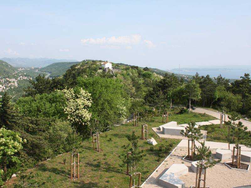
The Astronomical Centre Rijeka is surrounded by the park with natural sub-Mediterranean vegetation. A path leading through the park and forest connects it with the nearby church of Sv. Križ. Several archaeological fragments witnessing the continuous use of the fortress during the prehistoric and antique period have been discovered on the southern slopes of the Sv. Križ Hill, which makes it the oldest archaeological site in Rijeka. The park was declared cultural heritage of the Republic of Croatia in 2006.
Rijeka Walking Paths
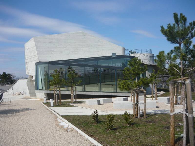
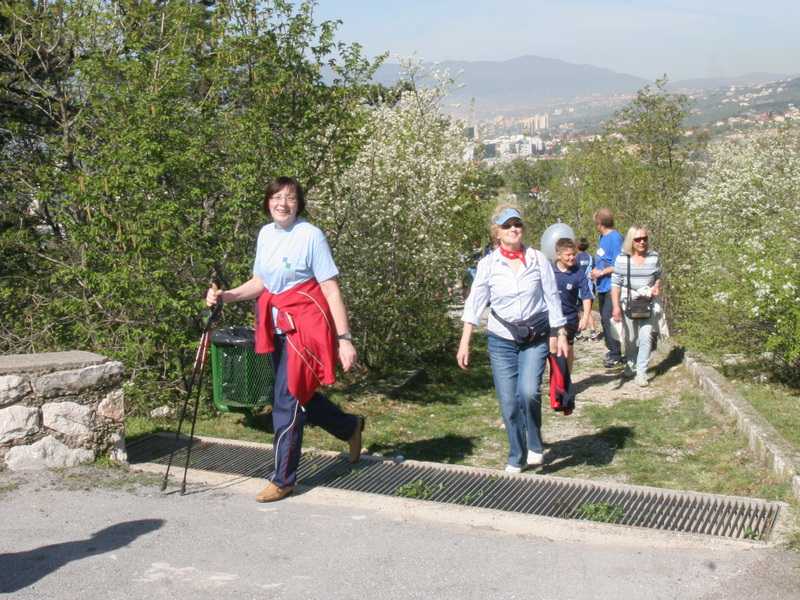
The Astronomical Centre Rijeka is one of the stations along the first section of the walking path, running from Plumbum to Trsat. Its terrace offering stunning view of the Kvarner Bay and the hinterland represents the most attractive spot along the first section of the pathway. Take a short break and you will be granted a manifold reward – you can watch a film in the planetarium, observe the stars or indulge in a coffee served on the upper, panoramic terrace. Or maybe you prefer to take a stroll through the Sv. Križ Park and pay a visit to a small early baroque church?
The first section of the walking path is 11.5 km long. It starts at Plumbum, and continues along the urban districts Donja and Gornja Vežica, Sveti križ and Strmica until it reaches the district of Trsat. The single sections of the walking path were named after famous autochthonous Mediterranean plants; pine tree and heather (Donja Vežica - Gornja Vežica), maple and mallow, (Gornja Vežica - Sveti Križ), ash and rosehip, (Sveti Križ - Sveta Ana), oak tree and sage (Sveta Ana - Strmica – Trsat).
The walking paths are mainly intended for leisure. However, they are also suitable for education, exploring flora or spatial orientation. As such, they add a valuable contribution to the local tourist offer.
Rijeka – the view from the lookout point in front of the observatory
The Primorje-Gorski kotar County stretches over 3590 km2. According to the last census in 2001 its population totals 304.410 inhabitants. The city of Rijeka with its 147.410 inhabitants is the third largest town in Croatia and the administrative centre of the Primorje-Gorski kotar County. It is situated in the Bay of Kvarner in the northern part of the Adriatic Sea. Nowhere else does the Mediterranean Sea penetrate so deep into the European continent like here, where it almost reaches the middle European countries. Due to the proximity of the Mediterranean Sea and its location in the middle of the North Temperate Zone (latitude 4521' N, longitude 1426' E) this region has a very pleasant Mediterranean climate with warm summers and mild winters. The average temperature in July is 23C and in January 5,2 C, the average yearly temperature being 13,8C. The mountains surrounding the Kvarner Bay, Učka, mountains of Gorski kotar and Velebit in the south, provide a splendid sight, which is particularly impressive when approaching Rijeka from the seaside. Rijeka is also known as a "museum town". In the shadows of ships made of steel, it conserves a rich cultural heritage of exceptional value. Rijeka (the River) is one of the few towns in the world whose name is related to water. It is divided by the river Rječina (the great River), a karst river which supplies the town with healthy drinking water. Rječina originates in the hinterland of Rijeka, some 17km away from the city centre where it flows into the sea.
Interesting facts about Rijeka
- Rijeka is a town with the greatest number of baroque altars on the eastern side of the Adria
- the first steam engine in South Eastern Europe was put into operation in Rijeka in 1833
- the first Croatian museum was founded in the fortress of Trsat in 1843
- the first torpedo in the world was constructed and produced in Rijeka in 1866
- in the19th century professor Peter Salcher from the Naval Academy in Rijeka was the first person who managed to photograph a flying bullet
- the first sterilisation of surgical instruments by iodine tincture was performed in the Rijeka hospital in 1911
- the symbol of Rijeka is Morčić, which is often found in traditional female jewellery – a bust of a black man with a turban is used as decoration on earrings, pins, rings and other jewellery
Podvežica – Sveta Ana
Sveta Ana (Holy Ana), nowadays part of the Vežica district, used to be a large estate stretching from Kalina to the Karoline Road. In the place of the pedestrian bridge there was a large entrance door topped by an arch with the following Latin inscription: "Benedicte montes et colles Domino, benedictae universa germinantia in terra Domino!" – "May mountains and hills and everything that grows on the earth praise the Lord! ". The estate belonged to the family Diminić until it was bought by the family Zandonat, who owned it from 1713 until 1819, after which it was known as Zandonatovo or Gospodstvo. A chapel of Holly Ana of which only a statue of the saint has remained was erected on the estate. Later, the statue was placed in the front wall of the family house Rahelić, nowadays one of the oldest houses in that part of Vežica. The holy Ana was worshiped for centuries, which is why she became the protectress of the parish Gornja Vežica.
Gornja Vežica
There is still no onomastic explanation for the toponym Vežica. In the past, the territory of Vežica consisted of several smaller settlements: Marčevo selo, Paškvani, Bobovo. The lower part of Vežica referred to as Podvežica had all the characteristics of a village. Small one-floor houses had a living space on the first floor connected by the stairs from the outside, whereas the stall was situated under the vault, also described as skod or skadanj. The Vežica district is a young settlement. The first blocks of houses were constructed in 1970s and were popularly called the "Chinese wall"due to their aspect. A modern building of the elementary school Gornja Vežica was constructed in the same year.
View from Draga
The Draga settlement is situated under the hill Rebar next to the valley described by the toponym Draga. The Rijeka - Zagreb railway which was constructed in 1873 and the Karoline Road run through the settlement.
Holy Cross Hill
The Holy Cross Hill has an elliptical shape. It stretches over 850 metres along the West-East axes, and over 100 metres along the South-North axes. Its total surface is 8,5 hectares. The average yearly temperature is 13,6 C with extreme values ranging between -9C and +37C. The relative humidity is between 65 and 75% and it is higher in the morning than in the evening hours. The average precipitation level is 1720l/m2 with 60 to 70 rainy days per year, whereas the average annual solar insolation totals to 2000 hours or 83 days a year. When the sky is clear, and especially after the wind bora calms down, visitors can enjoy a marvellous view of the Kvarner Bay, together with the islands Cres and Krk, the Učka mountain and the nearby settlements in the western part of the town. Towards the East, the view is barred by the hills Rebar and Solin. Before the construction of the Holy Cross chapel, the hill was called Vežica, which partly explains the origin of the old name Podvežica and the new name Gornja or the Upper Vežica.
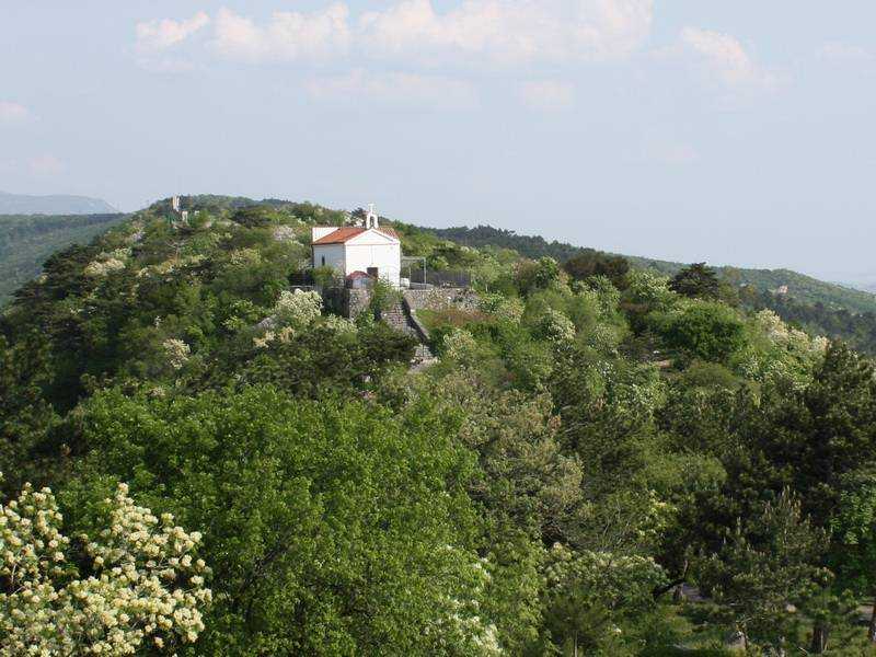
The Sv. Križ Church
In the place where the main bastion of the fortress used to be, nowadays there are still hips of stones on both slopes of the hill and a small church of the Holy Cross often referred to as a chapel. In a document dated 1670 a chapel of Holy Cross is mentioned: "Sveti Križ nad Vezichu" – The Holly Cross above Vežica.
Although the exact construction date is unknown, a historical document mentions acquisition of a new painting in 1607. Several names of the local donors appear in another document dating back to 1666.
According to a legend which suggests its old age, the church was built by the old Greek. An inscription of the year 1667 was found on the window and another one, dating back to 1670 on a chandelier. Locals used to pilgrim to the church when in need and in 1724 they pled for help against the cholera.
The chapel bell bore the following inscription: "Z.D. Ton. Batista 1634.", which means it was cast by John the Baptist. During the WWI the bell was taken off and it was used for casting weapons.
As time passed by this important heritage started deteriorating and an initiative had to be undertaken in order to save it from decay. This was arranged by Monsignor Burić, Monsignor Pavlišić and pastor of Donja Vežica, Monsignor Popović. The architect Zdenko Sila was entrusted with the reconstruction which started in 1976. He was assisted by Josip Matković from Podvežica, Anton Rončević from Krimeja and Grga Komadina from Gornja Vežica. The parish of Holy Ana was established in 2002. Since there are no other sacral buildings in Gornja Vežica, the chapel is occasionally used for liturgical purposes during certain festivities (Exaltation of the Holy Cross, Corpus Christi, Via Crucis). The facade, the electric line and the roof of the chapel have also been fixed.
Karst
Karst is a specific landscape with mostly subsurface circulation of water in limestone, dolomite and tuff. It is shaped by dissolution of limestone in the water which contains carbon dioxide. The limestone corrodes stronger and faster if situated under a layer of plants, in the soil rich in humus. Under such conditions, biological processes result in carbon dioxide which is more reactive than the one contained in the air or rainwater. Due to corrosion the cracks in the karst become larger and they gradually connect into a network of subsurface holes and channels which can reach great depths, sometimes even bellow the sea level. When limestone dissolves, some insoluble mineral nutrients in which metal oxides prevail remain and give red colour to the earth commonly known as crvenica or crljenica. Water running along slanted limestone surfaces creates hollows and furrows known as škrape. Funnel-like hollows and sinkholes are generated by extensive fissures on the surface, but they can also occur if the upper layer covering a hole breaks down. Some sinkholes are filled with earth which makes them even and very attractive for agricultural use in this part of Europe. Rivers running on the surface which suddenly disappear underground through fissures and swallow holes are called subterranean rivers. The karst area is rich in natural springs, water springs beneath the sea surface and shorter watercourses which play an import role in drinking water supply.
The prehistoric fortress on the Sveti Križ Hill
Throughout its existence, the fortress on the Holy Cross Hill was influenced by the events in the Draga settlement and the Martinšćica Bay. Natural springs and fruitful soil existed on both sides of the hill. Together with the protected harbour, they were used by Liburnians who settled down in this area. In the middle of the fortress is a thirty metres wide plateau with a lower, up to twenty metres wide terrace, running parallel along its southern edge, whereas several smaller terraces can be found on the north side. In the east, the plateau narrows and steeply drops into the valley of Draški potok, a stream separating the Holly Cross Hill from the nearby fortress on the hill of Solin above the city district of Kostrena. The edges of the plateau and terraces are surrounded by the layers of the so called "black land", a cultural layer from which we can learn more about the past inhabitants of this area and their activities.
On the southern slopes of the Sv. Križ hill, which are sunny and wind-protected and thus more appropriate for living, several fragments witnessing continuous use of the fortress in the prehistoric and antique period have been found.
In a courtyard of a family house a small statute of the famous Capitoline Wolf was discovered. The laboratory of the Institute of Archaeology in Zagreb has confirmed the antique origin of the statue which is very rare and seldom to be found in our museums. Upon the conservation treatment in Zagreb, the statue was brought to the Maritime and History Museum of the Croatian Littoral in Rijeka. Apart from the prehistoric pottery, numerous fragments of Antique and Roman pottery were discovered. They are remains of Roman amphorae from the Late Republic, produced in the delta of the river Pad during the 1st and 2nd century b. C., before this part of the Adriatic Coast was finally joined to the Roman Empire.
On the Sv. Križ hill a small plate made of fire-clay was found. Even though it bears the shortest inscription in glagolitic writing, it is one of the most valuable glagolitic artefacts found in the surroundings of Rijeka. It was not possible to deduct the complete meaning of the text written on the fragment since there were only four letters that remained preserved ("jat", "s", "a" and "e"). Nevertheless, this fragment is special because it is the only glagoltic inscription found, which was written on a fire-clay. Based on the shape of single letters it was possible to place it at the end of the 13. century, which ranks it among the oldest glagolitic inscriptions discovered between Plomin and Senj.
On December the 1st 2004 a plate made of clay with a Glagolitic inscription was found on the Holy Cross Hill. A group of pupils guided by their teacher Maja Crnić was visiting the location when they spotted the plate during an outdoor lesson. The pupils came from the fifth and sixth grade of the elementary school Gornja Vežica and attended archaeology as an extracurricular activity.
Sveti Križ is the oldest archaeological site in Rijeka. It was declared cultural heritage of the Republic of Croatia in March 2006.
Military Stronghold on the Sveti Križ Hill
During the WWII the Italian occupation army turned this locality into a military stronghold, due to its important, strategic position. On the western slopes of the hill the Italian army erected a strong fortress with a military settlement and an access road. Nowadays the fortress has been converted into the Astronomical Centre Rijeka.
On the eastern slopes of the hill where the historical structure used to stand, the Italian army built huge concrete bunkers on both sides of the hill and bellow the plateau it constructed a network of underground dykes and tunnels with several entrances on both sides. The earlier mentioned access road led to the top of the southern slope, where the main entrance was.
On the eastern side of the hill they pierced the rock in order to be able to access the underground tunnel which served as a shelter. On the top of the northern slope, on its eastern side, visitors can still observe a fifty meters long dry stone wall with fundaments of a small building, which was probably used as a military shelter.
The remains of the former prehistoric settlement on the plateau were probably removed in this period, during construction of military facilities.
Vegetation on the Sv. Križ Hill
The Astronomical Centre Rijeka is surrounded by green – a park with natural sub-Mediterranean vegetation is home to bushes and low-growth trees such as the oriental hornbeam, common oak and black pine.
In the 1970s most of this area was covered in rocks. Due to reforestation initiatives 5000 seedlings of black pine were planted. Nowadays, they have turned into a forest with self-grown deciduous vegetation growing in between, since the trees protect it from the wind from all directions.
The plateau is exposed to cold gusts of wind from the mountains and mild influence of the sea from the south, which is why this area is very reach in medical and aromatic plants.
Martinšćica – the view from the eastern side of the hill
Between the city districts Pećine and Kostrena you will find a well protected bay of Martinšćica. It was named after the chapel Holy Martin which used to stand here. During the extension of the port of Rijeka at the turn of the 18th to the 19th century there was a hospital which served as quarantine for the seamen and goods before they would be aloud to enter the port. The coastal road Dorothea connecting Rijeka and Martinšćica via Pećine once passed through here. It was reach in springs and waterfalls which used to turn the mill wheels and supply the eastern parts of the town with drinkable water. This was also the favourite bathing beach for those who lived in the city districts of Vežica and Kostrena until it was turned into a shipyard at the end of the last century
(Sources: Sušačka revija magazine, parish of Holy Ana - Gornja Vežica/ Župa Sv. Ane - Gornja Vežica, elementary school Gornja Vežica / OŠ Gornja Vežica, Academical Astronomical Society Rijeka / Akademsko astronomsko društvo Rijeka)